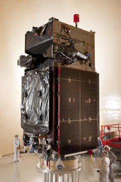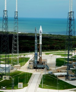
A new set of powerful infrared eyes should take up residency in orbit, more than 22,000 miles above our heads, in less than a week’s time, when the Pentagon launches the next member of its multi-billion-dollar Space-Based Infrared System (SBIRS). Liftoff of the GEO-2 mission—the second satellite of its generation destined for Geosynchronous Earth Orbit—is currently scheduled to take place from Cape Canaveral Air Force Station, Fla., atop United Launch Alliance’s venerable Atlas V 401 booster at the start of a 40-minute “window,” which opens at 5:21 p.m. EDT, 19 March. Processing for the impending mission continues to go well, and the SBIRS GEO-2 satellite was encapsulated in its two-piece payload fairing on 4 March, ahead of stacking atop the Atlas.
According to the Pentagon and SBIRS’ prime contractor, Lockheed Martin, the system represents the latest effort to replace the outdated Defense Support Program (DSP) network of infrared missile early-warning satellites, whose ancestry stretches back to the early 1970s. It is confidently expected that SBIRS will enable the United States’ space surveillance needs for at least the next two decades, with specific focuses including advanced early warning, missile defense, and battlespace characterization. In its final form, it will comprise at least four satellites in geosynchronous orbit, together with sensors aboard two others in highly-elliptical orbits (HEO-1 and 2)—which were launched from Vandenberg Air Force Base, Calif., in June 2006 and March 2008—and an expansive ground-based command, control, and data-processing network. Following numerous delays caused by software malfunctions and other hardware deficiencies, the first dedicated Geosynchronous Earth Orbit (GEO-1) SBIRS was successfully lofted from Cape Canaveral atop an Atlas V 401 in May 2011.

This triumphant launch marked the culmination of a long and tortured development process, which saw the SBIRS project costs literally balloon by over 400 percent from an estimated $4 billion to over $17 billion. According to General Accounting Office auditors, and reported by Defense Industry Daily in February 2013, it suffered from “immature technologies, unclear requirements, unstable funding, underestimated software complexity, poor oversight, and other problems.” The U.S. Air Force’s apparent lack of alternatives for an urgent national requirement to have an advanced surveillance system in orbit to monitor ballistic missile launches and nuclear events seems to have prevented SBIRS’ cancellation. Originally scheduled to fly a decade ago, only now is the project gradually reaching fruition.
The second satellite, GEO-2, is expected to enhance the Pentagon’s surveillance capabilities yet further. Speaking in August 2011, Col. Scott Larrimore, chief of the U.S. Air Force’s SBIRS Space Division, described these capabilities as “much needed.” They include highly sophisticated scanning and staring sensors, with improved infrared sensitivity and the scope to provide a wide-area (“scanning”) surveillance of missile launches and natural phenomena across the planet, as well as observing smaller regions (“staring”) with superior sensitivity and reliability. Currently, Lockheed Martin’s SBIRS contract encompasses four HEO payloads, four GEO satellites, and ground-based assets, although the option exists for future fifth and sixth GEO missions.
SBIRS GEO-2 will fly atop the “401” configuration of the Atlas V, with a 4-meter (13-foot) payload fairing, no strap-on rocket boosters, and a single-engine Centaur upper stage. The 401 is identical in physical appearance to the vehicle used for the launch of NASA’s latest Tracking and Data Relay Satellite (TDRS-K) from Cape Canaveral in January, as well as last month’s Landsat Data Continuity Mission (LDCM) from Vandenberg. Since its maiden voyage in August 2002, the Atlas V has flown 36 times with a near-perfect launch record. Its only blemish was a Centaur upper stage problem in June 2007, which produced a lower than intended orbit for its classified National Reconnaissance Office primary payload. Capped-off by its bulbous, two-piece payload shroud, the giant rocket stands almost 19 stories tall.
Should the launch of SBIRS GEO-2 occur on time, the Atlas will rise from Space Launch Complex (SLC)-41 into early-evening Florida skies in what promises to be a spectacular sight for viewers along the Space Coast. The Russian-built RD-180 engine will roar to life, approximately 2.7 seconds before liftoff, burning liquid oxygen and a refined form of rocket-grade kerosene, known as “RP-1,” and producing 860,000 pounds of thrust. Climb-out from SLC-41 will commence at T+1.1 seconds, and the avionics of the Centaur upper stage will command a pitch, roll, and yaw maneuver to establish the vehicle onto the proper flight azimuth, following an easterly trajectory to inject SBIRS GEO-2 into orbit.

In total, the RD-180 will burn for a little over four minutes, shutting down at T+243 seconds, to be followed by the separation of the 41-foot-long Centaur and attached payload. To support the deployment of SBIRS GEO-2 into its correct orbital “slot,” the upper stage will perform two lengthy firings of its 22,300-pound-thrust RL-10A engine. The first, lasting 11 minutes, will place the combo into a “parking” orbit, after which the two-piece payload fairing will be jettisoned, exposing the satellite to the space environment for the first time. A nine-minute coasting phase will be followed by a second burn, lasting nearly four minutes, and a 15-minute coast. Assuming an on-time liftoff, SBIRS GEO-2 will be released from the Centaur to begin its mission about 43 minutes after leaving Cape Canaveral.
United Launch Alliance, for whom the launch of this important surveillance sentinel will mark their third mission of the year, are entirely aware of its importance. According to Jim Sponnick, ULA’s vice president for Mission Operations, the new satellite “will provide the nation with significantly improved missile warning and defense, battlespace awareness, and technical intelligence.” Its sensors are considerably more flexible than the earlier DSP, and their capacity to detect short-wave and expanded mid-wave infrared signals enable SBIRS to perform a broader set of tasks. The satellite network will be operated by the U.S. Air Force Space Command.
Missions » SBIRS » GEO 2 »


One Comment
One Ping
Pingback:Atlas V with SBIRS GEO-2 satellite ready for Launch – Wired4Space